Day 5 started badly. For some unknown reason, I could not sleep the night before our planned 4 AM wake up and drive to the top of Haleakala to experience the sunrise. But damn it, we’re on vacation and we’re going to have fun, so I took the wheel and drove us the 50 miles to the summit. The last 23 miles of the drive was up about 5000 vertical feet on an insanly narrow two-lane paved road with about a hundred hairpin turns. We arrived just as the horizon was starting to turn orange.
We had about 40 minutes to stand in the cold wind before sunrise.
It was almost pitch dark as we walked up the trail to find somewhere to watch, so we didn’t see the many warning signs reminding us to stay on the trail. At 6 AM in the dark, everything looked like barren lava to us. At 6:30, an angry ranger came walking up the trail and barked at a group of us to get back on the trail. Two others who had strayed even farther got a “THAT IS A DIRECT ORDER” from Mr. Angry Ranger.
The sky kept getting brighter
And brighter until finally the golden rays broke free of the clouds, blinding us with light, but not warmth.
The sunrise on the top of Haleakala was astoundingly beautiful. The area from which we were viewing it put us at the junction of two large valleys incorrectly referred to the crater. As we looked down and across the crater, numerous cinder cones and lava fields colored wild shades of orange, black, green, purple, and gray burst into color as the sunlight spilled onto them. Was it worth the nasty drive and bone-chilling cold? You bet.
It was bugger-cold; after all, the summit is at 10,023 feet. I had jeans, two shirts, a fleece jacket, a rain jacket, fleece hat, and wool mittens on and I was still freezing. What kind of attire is that for a Hawaiian vacation?
There was no snow, although we could see lots of snow on Mauna Loa across the ocean channel to the Big Island, but there was proof of freezing temperatures in the frost on the trail.
As the world grew lighter, we could see why Angry Ranger had yelled at us. When we hiked off trail, we found ourselves in a small roundish low shelter surrounded by lava boulders. We thought it was just a modern assortment for watching the sunrise, but no, it was a pa, a shelter built by native Hawaiians and a protected archeological resource. Big oops. There was also endangered species habitat.
We took a quick nap in the warm car and ate a few snacks before we set out on a hike on the Sliding Sands Trail down into the crater.
The landscape in the crater/valleys was lunar-like. On the older lava, tiny plants have established, but everywhere else is a sea of porous, abrasive lava.
Although it was very cold and very windy, Drew flushed out what we think was the Hawaiin state bird or nene. It looked like a Canadian goose. Incredible that any creature that big could be living here.
The nine individual cinder cones were even more visible as we descended into the crater. All the lava in the photos is between 900 and 5000 years old, which is pretty young as far as rocks go, but it amazes me that there is so little soil development on it.
After our hike, we drove over to the nearby peak where several observatories and a short interpretive trail are located. We saw lots of these native plants called ‘ahinahina or silversword.
Biologists believe the plant came to Hawaii about a million years ago on the feathers of a bird. Since then it developed into a hairy little mound of thick leaves to retain moisture and ward off the intense sun at this altitude. The plants may live 50 years but only bloom once.
Drew drove down the mountain while I barely hung on to my stomach and achy head. We stopped for some Tums and potato chips, which was a recipe for tummy happiness. Feeling better, but still very tired, we napped again at the condo, ate some pineapple bacon sausages again at the pool, and napped a bit longer.
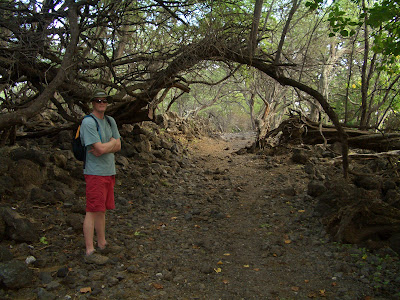
By 3:30 PM I was feeling human again, so we loaded up the snorkel gear and boogie boards and drove south to the end of the road. Literally. The road goes through the island’s youngest lava flow (about 500 years old), designated the ‘Ahihi-Kina’u Natural Area Reserve. At the end of the road is La Perouse Bay and a place called Aquarium, which is supposed to have the island’s best snorkeling. However, on this day…Goat poop! Due to the large amounts of rainfall four days prior, a lot of runoff from the island had entered the water. Most of the beaches on this leeward side of the island were still closed due to all the runoff from the storm. A Friendly Ranger was parked at the beach, warning people not to attempt snorkeling. So instead, we went for a hike on Hoapili Trail along the shore of La Perouse Bay
Through very cool forest
and pretty shoreline
and onto the lava field at Cape Hanamanioa. The lava here looks almost like a freshly plowed field, only chunkier and rougher. It is a’a lava, formed from more viscous, drier lava that doesn’t really
flow but
lumbers along in chunks.
It was a nice dry alternative in lieu of being able to get wet.
And finally, what island vacation would be complete without fruity drinks at Moose MacGillicuddy’s. Kahlua pork quesadilla and a burger for dinner before an early bedtime.


