Coffee is important, especially when the day promised 43 miles, two mountain passes (5000 feet of climbing) and lots of single track.
We hit the trail at 9:30 but soon stopped to cheer that the huge tree that had fallen on the road had been cleared for us.
We biked on the historic Barlow Road, which was built in 1846 to serve as the last overland segment of the Oregon Trail. Its construction allowed covered wagons to cross the Cascade Range. Wikipedia says that it was by far the most harrowing 100 miles of the nearly 2,000-mile Oregon Trail.
Thinking about those pioneers, I wonder about my lifestyle. Here I am riding a bike for "fun" to "test my endurance" on the same road that 150 years ago pioneers risked nearly everything to traverse. What would a pioneer woman think if she could see me biking along as she nervously watched her children walk behind the wagon and fretted about how thin the soles of their shoes were getting? Odd? A useless waste of energy? Stupid girl?
People died making the journey West, and here was proof
Pioneer Woman's Grave
The Pioneer Woman's Grave is a monument to the grave of a pioneer woman that was uncovered in 1924 by a highway survey crew.
My somber thoughts were amplified by the fog and mist that enveloped us. What could bring me out of my melancholy? A four-lane highway to navigate!
To be honest, we were only on Hwy 35 and then Hwy 26 for less than a mile, but it was quite the rude awakening after two days of bike pioneering.
The clouds were thick and Drew and I were beginning to worry about rain. We had not seen a weather forecast for days, but by the look of the sky, we were in good shape to get wet, and we had 30 miles to go.
Still, we couldn't miss what the directions said was a beautiful lake. I think we were all underwhelmed by Trillium Lake.
Our Trillium Lake
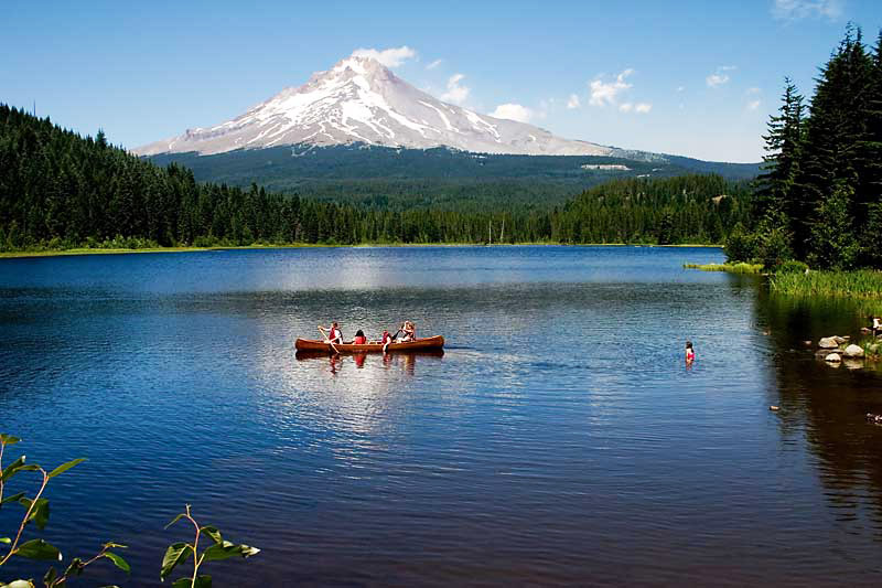
But that is because we didn't realize it could have been spectacular. Here is a photo from Wikipedia taken from the same spot as above.

The possible Trillium Lake
Guess this is one of those times when you didn't "just have to be there".
The next stop was civilization, i.e. the town of Government Camp. With my excellent navigational skills ;-) yet horrible navigating device (Garmin 500 bike/race GPS) I missed a turn and almost sent us around the town on boring dirt road. I caught my mistake before too much damage was done though and soon we were in a convenience store snarfing corn dogs, hot dogs, potato chips, donuts, and hot coffee. It started to drizzle just as we got to the store, which I just took as an excuse to eat that second corn dog.
It was 1 o'clock and we had 26 miles to go. Time to descend on the uber fabulous Crosstown Trail.
The pictures don't show you how fast and flowy and majorly green the trail was. Even on the forest floor in the seemingly dark shade were ferns and plants unknown to this desert dweller. The trail was pretty narrow and fast enough to need some slightly banked turns. The route had a few tiny climbs but the Crosstown mostly consisted of just ripping through the misty forest with my friends - special times they were!
The Crosstown trail gave way to a tunnel
and the famed Pioneer Bridle Trail. We all agreed that the Crosstown Trail was actually more fun to ride than the PBT, but for sheer otherworldly environment that made you feel as if Sasquatch was going to come hammering up the trail on a singlespeed bike at any minute, PBT took the prize.
Part of the Pioneer Bridle Trail that Drew termed Chlorophyll Alley
To the town of Zig Zag and a quick shot of jet fuel (mocha lattes) to put some energy in the tank for the 2000 feet of climbing ahead.
A tiny bit more trail and then it was all this.
For 8.5 miles we climbed a paved road that started out as a two-lane road having cute and interesting houses to look at, to a less than one-lane road that was lined for miles and miles with foxglove.
I love foxglove, but have had no luck growing them here in the desert. I guess roadside "weeds" in the wet of Oregon can't be expected to thrive in Utah.
After 42 miles and 9.5 hours out in the mist and clouds, we reached "the gate". Each hut had a locked gate very near it, which told us we were close.
Only another half mile to Lolo Pass Hut!
The clouds prevented us from seeing Mount Hood, which we knew was close, but even so, they made for a peaceful, cozy feeling.
Cozy that is until you came into a hut full of stinky bike gear hanging from the rafters.
But look at the size of that cooler! Good microbrews in there too!
Shelly once again proved she can put in the miles and still cook up a mean bowl of pasta.
A board game of "Battle of the Sexes" did nothing to come between me and my honey after a loooong day on the bikes.
3 days down, 1 to go.


No comments:
Post a Comment