
On the morning of Day 1, June 4, I woke up excited to see what our river trip would be like. We had stayed the night at Cliff Dwellers' Lodge, near Marble Canyon, a few miles from our put-in spot at Lee's Ferry.


Breakfast with Judy (taking the picture) and Brian after my hike.

And then the group was picked up by Steve Hatch, the grandson of Bus Hatch, a pioneer of commercial river running and founder of Hatch River Expeditions. We were transported to the boat ramp at Lee's Ferry. There were a couple of other groups putting in at the same time.

We met our guides, got fitted with life jackets,

and loaded up in the two big boats that would take us down the river.

Our guides immediately struck me as laid back but in control. Our trip leader was Don, who had been guiding river trips for 35 years.

Don
Driving the other boat was Bubba, a.k.a. Matt.

And the "swamper" or helper and guide-in-training was Dom, a young, fun-loving guy with a lovely singing voice, as we would hear later.

Dom
Lee's Ferry
All upper canyon river trips put in at Lee's Ferry, which was the only place to cross the Colorado for many, many miles until 1927 when Navajo Bridge was built. After John Doyle Lee's participation in the Mountain Meadows Massacre, Lee was excommunicated from the Mormon church and sent in 1870 by Mormon leader Brigham Young to this site at the mouth of the Paria River to create and operate a ferry crossing. He did so only until 1874 when he was arrested and later executed for his role in the Massacre. The ferry, however, was an important link between the north and south rims from 1870 to 1921.*
* Most of the historical stuff in these posts and some of the geology I am lifting straight out of two good little guidebook:
1. Belknap's Grand Canyon River Guide, 2012 edition. 2. Crumbo, Kim, 1994, A river runner's guide to the history of the Grand Canyon: Boulder, Colorado, Johnson Printing Co.
Soon we pushed off from Lee's Ferry and we were underway, but all we did was drive across the river to have our first geology stop!
I was determined to take notes of it all.

GEONOTE
We were we looking at the last of the Mesozoic rocks that we would see. These rocks were deposited between about 240 and 70 million years ago (Ma) in large sandy deserts and in rivers and lakes in a tropical climate.

We waved goodbye to the Mesozoic and pointed out boats downstream.
UNDERWAY
A little boat nomenclature to start off. This picture illustrates the four places to sit on these large boats.

At the front of the raft, about 4 or 5 people can sit with their backs leaning against the pile of duffle bags under a tarp. This spot is called the "the bathtub", so named because you will get very wet in the rapids. Here are Sharon from Iowa with Judy and Brian sitting in the bathtub.

Then there is "Butts to the Boards", where you also sit with your back resting against the duffle pile, but here you are facing out to the side of the boat. You can also sit on the pontoon until the guide tells you not to in big rapids.
The last place to sit is shown in this next picture. The two guides are in back of the raft and Carol and Jordan are in the "tea room", so named because you can sit properly and not get (very) wet.

We didn't really have our "boatlegs" yet, but it wasn't long until we saw something cool.

At about river mile 4 we passed 450 feet below Navajo Bridges,

the first of which was built in 1929, establishing a very important transportation route across the river to replace accident-prone Lee's Ferry. The second bridge was built in 1995, so now the first bridge is for pedestrians only. This is the last place you can cross the Colorado in a car until the Hoover Dam, 350 miles downstream. Some of our party also saw what they thought was an eagle resting in the struts.
GEONOTE

While others were looking up at the bridges, I was taking pictures of rocks. This picture, taken from under Navajo Bridge, shows the youngest formations of the Paleozoic section. For most of the Paleozoic (570 to 240 Ma) the area that is now the Grand Canyon was covered by shallow warm seas. The Permian Kaibab Formation (Pk), mostly limestone and sandstone, forms the rim rock for most of the canyon, and the surface of the Kaibab Plateau for hundreds of square miles on either side of the canyon. In these first few miles, we were up close and personal with the Kaibab.
Below the Kaibab is the Toroweap Formation (Pt). Both formations are later Permian in age and deposited in warm shallow seas or tidal flat environments.
I will be talking a lot about rocks in these posts. This trip was the best 7-day geologic excursion I will probably ever have the good fortune to experience and I want to remember as much of it as I can, so either bear with me and you might learn something, or just skip past all the geo-geekiness. If you are into learning, here is the first bit you might want to study.

This is the stratigraphic column, or strat column. The strat column shows the age, thickness, and relative resistance to weathering of the geologic units from the youngest at the top to the oldest at the bottom. One of the most amazing things about this strat column, and I say that meaning THE MOST AMAZING thing about the entire trip, is that we can, in some places in the canyon, actually see almost all of this column in one view! As a practicing geologist of 17 years with 7 years of college geology field trips taken to many outstanding geologic locations prior to this trip, I have never in my life seen so much of earth's history visible in one eyeful.
I will refer back to this strat column often.
NON-GEO COOL STUFF
Back to river stuff. We had our first real rapid - Badger Rapid at mile 8.
Badger Rapid and Badger Canyon
In the international rating system for difficulty and size of rapids from 0 to 5, this is a 2-3 (Grand Canyon uses a 0 to 10 system, but I will cut that in half to describe the ratings in the more commonly used 0 to 5 system). I think I was up front for this rapid, so I squealed with delight and got wet.
Next stop was lunch at Jackass Canyon campsite just below Badger Rapid.

Lunch Day 1 at Jackass Campsite. Photo credit: Jordan (note all of Jordan's date stamps are one day off.)
It was at lunch that I realized I would probably not be loosing weight on this trip! While we guests lounged about for a few minutes, the guides set up tables and laid out freshly prepared tuna fish salad, cold cuts, a half dozen kinds of bread and tortillas, sliced fresh vegetables, pickles and olives, hummus, potato chips, and 3 or 4 kinds of cookies. Not too shabby for a camping trip.
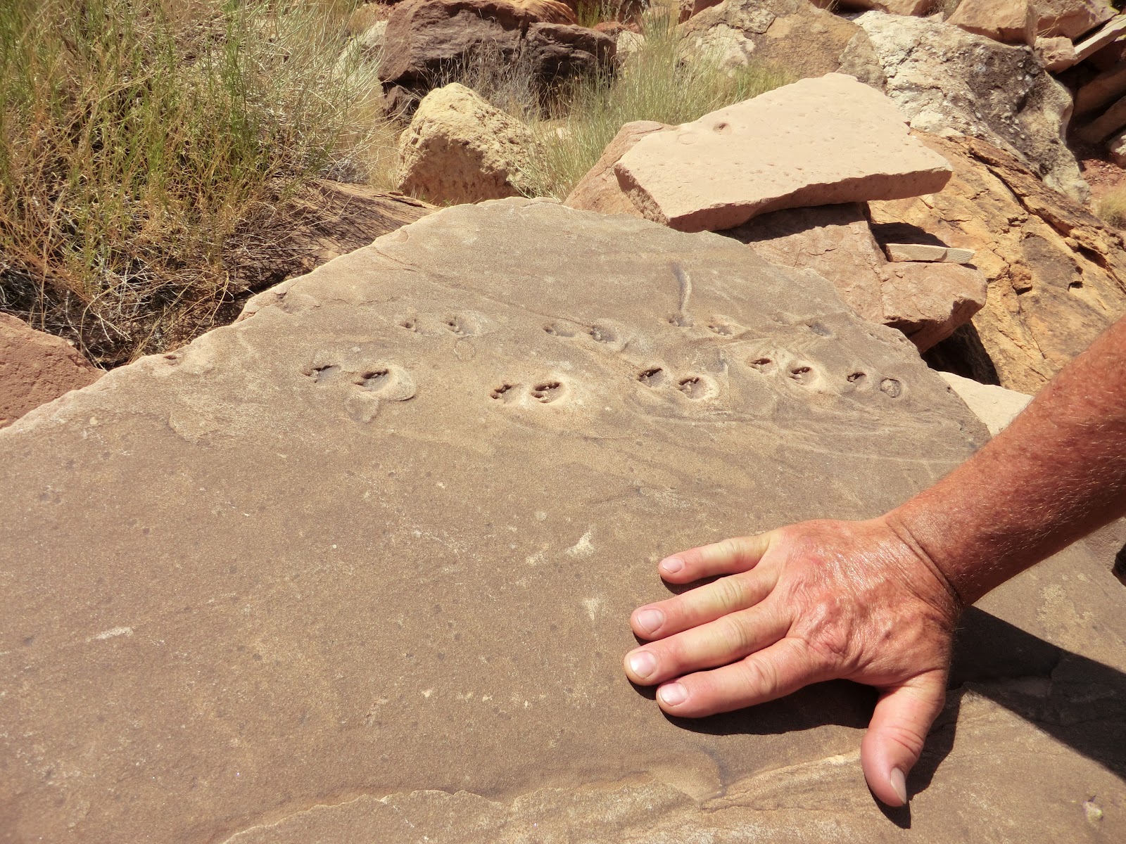
During the lunch stop, we took a little walk to view these petrified lizard tracks that I think Kata said were on a slab of Coconino Sandstone (~275 Ma), but they could be much younger.
We also saw some nice slickensides, which are the linear scratches left on this rock (pic below) from when rocks slide past each other on the plane of a fault.

Tim at slickensides at Jackass Canyon. Photo credit: Jordan.
After lunch we ran Soap Creek Rapid, which is only rated 2.5 to 3 in my guidebook, but which felt much, much bigger. I remember a big hole that the raft slid down into, dousing me completely with icy water.

Soap Creek Rapid. Photo credit Jordan.
This rapid historically gave the early explorers quite a bit of angst and proved to be deadly. The first expedition down the canyon was of course by Major John Wesley Powell in 1869. His crew probably either lined this rapid, meaning they tied lines to the boats and let them down through the rapid while the men walked along on the banks, or portaged the boats and all their gear around it on the banks. In 1889, the third expedition through the canyon, the Stanton-Brown railroad exploration expedition, lost leader Frank Brown here. In 1896 another expedition ran all the rest of the rapids, many of which are rated more dangerous than Soap Creek Rapid, except this one. It wasn't until 1929 when the sportsman's expedition of Parley Galloway and Clyde Eddy ran the rapid by mistake, thinking Badger Rapid was this one.
GEONOTE
By 2:30 p.m. we were already 100 million years down into the geologic section! We had seen all the Permian formations representing Earth's history from about 330 to 240 million years ago. We had the Kaibab and Toroweap, that I mentioned above, but also the Coconino Sandstone (Pc) (semi-arid dune environment), Hermit Shale (Ph) (river and stream channel deposits), all of the formations of the Supai Group (river, coast, and shallow sea repeated over and over again), and now we were into older Missippian-aged Redwall Limestone (Mr) (shallow and deep sea).

Many of the canyons features are named for geologic occurences. For the first couple of days, we were not rafting the Grand Canyon at all, we were in Marble Canyon, so named by Powell because he saw river-polished slabs of Redwall Limestone and thought it was marble. The Redwall has an interesting name as well. It is very resistant to erosion and very thick, so forms steep, tall walls that are stained red by the red silt and clay washed down from the Moenkopi Formation high above. The Redwall is in fact a beautiful alternating white and dark gray banded limestone formed in an alternating shallow and deep sea environment.
The Redwall is a prominent cliff forming unit. Being limestone, it also had solution features (caves and such).

CAMP NIGHT 1 SHINUMO WASH
At about 3:45 we pulled to the river left (left side looking downriver) to a big sandy beach to make our camp for the night at Shinumo Wash camp.

It was hot, so many of us sat at the waters edge waiting for the shade to hit camp.

It finally came, and the softer light allowed us to see the gray and white banding of the Redwall Limestone coated by red silt across the river.

Before dinner, Kata performed a Mongolian ceremony in which the oldest among us drinks (in this case, Templeton Rye Whiskey) from a little cup with his/her other hand on his/her elbow and then passes the cup around the circle.


But I guess I was so excited about the whiskey, I forgot the elbow rule.
It was a good way to get the evening started before our first camp dinner of caprese salad (appetizer), barbequed steak, mashed potatoes, tossed salad, grilled garlic zucchini, and chocolate cake (!).
Day 1: Amazing!
This is my first time to visit and your site and I don't know what to say but one things for sure you will doing a great job! Thanks for sharing!
ReplyDeletegrand canyon dory